Global Navigation Satellite Systems (2/2)
How GNSS works
The purpose of a GNSS is to calculate the location of a point on Earth, as well as it's elevation, in a known coordiante system. In order to identify one's location, a receiver is required that can receive the signals that the satellites are trnasmitting. The satellites are orbiting the Earth in a very precise and fixed orbit and their location is always known. They are also equipped with an atomic clock to ensure that all the satellites in the contelation are synchronised. The satellite continuously translits a signal that containst its location and the time of transmition. When the receiver records the signal, it compares the time the signal was transmitted from the satellite and the time it was received. Since the signal travels with the speed of light, by knowning the time it took the signal to travel, the receiver can calculate its distance from the satellite.
When one satellite is used as a reference point, all the possible locations at a particular distance from the satellite form a sphere. If a second satellite is used as an additional reference point then the possible locations that have those two particular distances, form a circle.
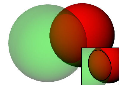
Source: Wikimedia Commons
When a third satellite is added then the common area between the two spheres are just two points. One of those two points one will not make any sense (it will either be in space or deep inside the Earth). So, a minimum of three satellites are required to identify one's location on the planet. However, in order to achieve higher accuracy, a minimum of four or even five satellites are required.
Differential GPS (DGPS)
When the GPS was first developed, it was aimed at military applications. In order to stop any military opposition from using the system to guide missiles or have knowledge of their precise location, a random error was introduced to the time signal, which could only be corrected if the used owned a passkey.
The Differential GPS (DGPS) is a network of stationary transmitters and receivers of known location. These recievers read the GPS signal and compare the resulting location to their actual one. The difference is the induced error, which is then transmitted to the users, who use it to correct their own signal from the GPS satellites.
Sources of error in GPS
Since GPS is the only fully operational GNSS, we will refer to it, but the principles remain the same for any GNSS.
In addition to the artificial error mentioned earlier, there are other sources of error in a GPS measurement. Capturing of a GPS signal requires that the satellties are in the line of sight, which means that there must by and unblocked path between the user and the satellite. This makes use of GPS problematic in a forest, or sometimes even in the city, when we are surrounded by tall buildings that block our view of the sky.
What is known as satellite geometry is also a factor that can cause large amounts of error, even if the minimum number of four satellites is achieved. If the four satellties are not evenly distributed in the sky visible to us, a small error in the signal will cause proportionalyl a large error, even in the range of 100 metres.
Finally, the path of the signal from the satellite can deviate from each path and effectively take longer to arrive to our receiver. The atmosphere is full of particles, gases and vapour that can scatter the path of the signal. Another similar effect is the reflection of the signal from nearby large objects, such as tall buildings in an urban area. These reflections also lenghten the path of the signal and effectively give a false estimation of our distance from that satellite.
