Is the Aral Sea reverting?
Tasks:
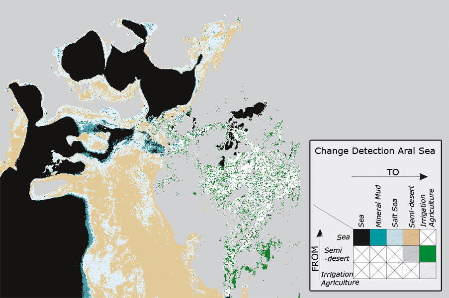
1. Explain the land cover changes in the northern part of the Aral Sea using the images and the map.
2. Predict the chances that the northern sea will gain volume.

Source: Beckel 2007
The ocean is reverting! The water level at least in the northern part of the Aral Sea is raising again, the smallest of the three seas grows again. Until 2005 between the small Aral in the north and the large Aral in the south, a dam supported by the World Bank was built. Since then, the water from Syrdarja has filled the small Aral Sea faster than was previously considered. Experts forecast that the northern sea will swell into a mass, to again aid industrial fishing and to balance the regional climate. The sea in the south will dry out now much faster; drawing its water out of the Amurdarja, where its delta is no more than a trickle. With this, the preservation of the largest part of the Aral Sea is virtually impossible (NASA, Schlager 2007).
Source: Beckel 2007
Information about the Map
- Basis: Landsat MSS, Landsat TM
- Image Dates: Summer 1973, 2000
The map has information won from the satellite images from the years 1973 and 2000 (see above). The change analysis shows the massive changes in regional land use, induced through the rash subsidence of the ground-water table. Very clear is the degree to which the sea is receding, and the consequential spread of half deserts and salt seas (Beckel 2007).