Source: Beckel 2007
Content:
The worksheet 'Rondônia' deals with the changes in the landscape and land cover caused by humans. Presented here is the "prime example" of fire clearance in the tropics which shows both the man caused change in land use and the ecosystem. Through the forest clearance of large forest areas their prior use as C02 sinks disappears. The forest clearance has other negative consequences such as the loss of biodiversity and negative effects on the global heat balance.

Source: Beckel 2007
Didactic Commentary:
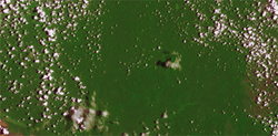
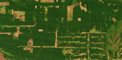
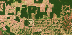
- In this worksheet the extreme changes of land use in the Brazilian region of Rondônia caused by forest clearance should be considered. Through comparing the three satellite images from the same region but from different dates, the clearance can be traced. The status in the 70's in the region was an untouched rainforest which has since been dispelled by farming and pasture lots; the reasons being the use of the areas for agriculture, cattle breeding ("beef steaks from Brazil") and plantations.
- To decisively answer the worksheet the students should be able to describe and analyse the three images for the first step. For this process, the images can also be individually discussed. For the next step, the students should present the changes in order to, for the next step, be able to identify their causes. For the last task, the students should think about how the region could be in a few years. For the visual learning types it would help to graphically display the changes. An option would be, for example, to construct one possible image for the future.

Source: Beckel 2007
Solution of the Worksheet 'Rondônia'
1. Describe the changes in land use in the region Rondônia using the satellite images.
In the first image from 1972, one can see a closed forest cover (tropical rain forest, primary forest), the white areas depict light clouds.
In the second image from 1986, the human interference (fire clearance) can already be seen. In the left quadrant of the image, there are large areas of deforestation, probably for plantations and cattle-breeding, and on the right side there are small areas of clearance. These have been placed on the edges of the newly built streets, very likely done by small farmers.
In the last image from 2000, almost the entire area has been taken over by human use, the large areas (plantations and pastures) have small deforested allotments, larger free areas exist now only in the left upperhand corner of the image.
2. a. Explain how these changes occur.
Reasons could be, among others: population growth, fire clearance, shifting cultivation, the introduction of large plantations and pastures for cattle-breeding, world-wide product exportation, exploitation of the rain forest through streets (highways, etc.)...
2. b. What role does the fire clearance play?
The fire clearance plays the central role with the changes that have come about. The large areas of deforestation for plantations and pastures have an enormous interference in the ecosystem and in the primary rainforest. The original form of fire clearance took care of the forests and was in a sense "sustainable".
2. c. Test your hypotheses using the text (in the module).
3. Design a future scenario for this region.
Example for a negative scenario: the remaining forest areas will be felled, the rain forest will disappear completely from the region, many species (vegetation and animals) disappear, and time after time the soil will be washed of nutrients, resulting in fallow land, erosion, and the depletion of vegetation and the agriculture until a change in the local climate and global climate...
Example for a positive scenario: with global support the fire clearances will be stopped, part of the areas will be re-forested, different species (vegetation or animals) will come back, and there is enough living area for the endangered animals, farming of the rain forest will be planned sustainably and long-term, plantations will decline, the pressure of the world market prices and then cultivation conditions change...