8. Image Credits
Chapter 2: Oil Pollution
|
|
|
|
|
|
|
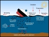
Inputs of oil entering the marine environment from ships and other sea-based activities
in the period 1988 - 1997
Last access: 09.06.2009
|
|
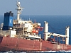
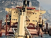
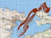
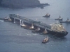
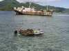
Partially sunk New Flame vessel after collision with an oil tanker
in the Strait of Gibraltar in August 2008
Last access: 18.12.2008
|
|
|
|
|
|
|
|
|
|
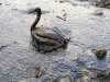
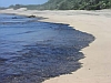
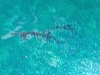
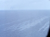
Recent spillage of oil
|
|
|
|
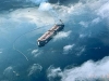
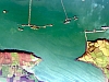
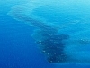
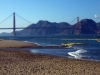
An oil slice approaching land, resulting from the Exxon Valdez Oil Spill in March 1989
Last access: 09.06.2009
|
|
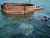
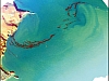
Oil slick visible on water's surface above the sunken battleship USS Arizona (BB-39)
in Pearl Harbor, Hawaii
Last access: 09.06.2009
|

|
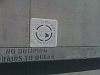
The hazard symbol for toxic/highly toxic substances according to directive 67/548/EWG
by the European Chemicals Bureau
Last access: 15.01.2009
|
|
|
|
|
|
|
|
|
|
|
|
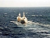
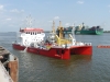
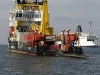
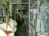
The German oil recovery vessel 'Knechtsand'
|
|
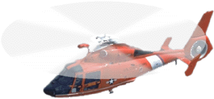
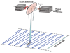
Helicopter of the United States Coast Guard with animated propellers (HH-65 Dolphin)
Last access: 06.01.2008
|
|
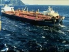
Exxon Valdez tanker circled with containment boom
Last access: 06.01.2008
|
|
|
|
|

|
|
|
Schematic illustration of an oil spill spreading on the sea surface
|
|
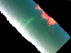
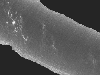
Airborne optical image of fuel oil on the sea surface
|
|
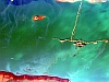
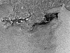
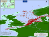
ASAR wide-swath image acquired 17 November 2002 showing an oil spill originating from the stricken
Prestige tanker, lying 100 km off the Spanish coast
Last access: 09.06.2009
|
|
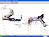
GIS screenshot with remote sensing data from the Sea Empress oil spill in 1996
|
|
|
|
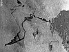
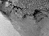
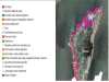
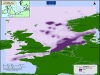
Fuel oil drift in the Kerch Strait 11-15 November 2007
|
|
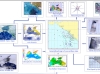
Schematic from the Black Sea showing how data from many sensors are put together to give an environmental map of the area
|
|
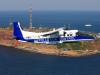
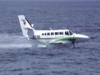
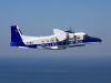
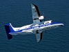
Maritime surveillance aircraft DO 228 of the Central Command for Maritime Emergencies (CCME) on scene in the North Sea.
|
|
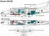
Remote Sensing instruments aboard maritime surveillance aircraft Dornier 228 LM
|
|
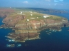
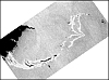
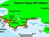
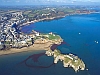
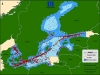
The Sea Empress aground off St. Anne's Head at the entrance to Milford Haven
Last access: 10.09.2009
|
|
Aerial photograph of the cliffs at St Anne's Head
|
|
CASI image showing brown streaks of oil off St Anne's head
|
|
CASI image showing oil leaking from the Sea Empress when docked in Milford Haven
|
|
CASI image of Milford Haven with the Sea Empress and streaks of oil sheen in Angle Bay
|
|
RADARSAT image of Milford Haven and Carmarthen Bay
|
|
ERS-SAR image of Milford Haven and Carmarthen Bay from 26 February 1996
|
|
CASI image from the Tenby area in Carmarthen Bay on 27 February 1996
|
|
Thermal infrared image from the Tenby area obtained on 27 February 1996
|
|
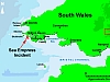
Map of South Wales and the Bristol Channel
|
|
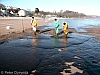
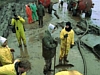
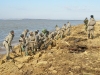
Clean-up at sea in the Tenby area of Carmarthen Bay on 27th February 1996
|
|
Cleaning up the beach in the Saundersfoot area of Carmarthen Bay
|
|
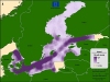
Map of South Wales and the Bristol Channel showing the shoreline most affected by oil of the Sea Empress
|
|
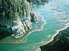
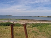
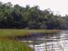
Angle Bay grasslands and intertidal mudflats
|
|
Oilspill cleanup in West Angle Bay
|
|
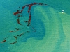
Surface oil in the Tenby area of Carmarthen Bay
|

|
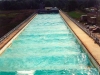
View from Saundersfoot Leisure Park across the Bay
|
|
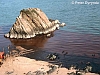
Surface oil around the rock in Saundersfoot Bay
|
Supplements
Supplement 2.1: Types of Oil
|
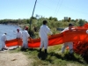
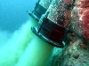
German coast guard ship putting up a containment boom
|
|
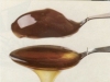
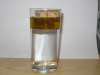
Two sorts of oil with different viscosity
|
|
Two sorts of oil with different viscosity
|
Supplement 2.2: Properties of Oil
|
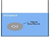
Water, oil and a cork
|
|
|
|
|
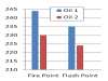
Flash and fire points of two different kinds of motor oil
Last access: 17.07.2008
|
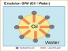
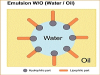
Supplement 2.3: Emulsions
|
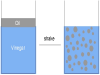
Oil in water
|
|
Emulsion
|
|
Oil-in-water emulsion
|
|
Water-in-oil emulsion
|
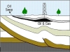
Supplement 2.4: Natural Oil Seeps
|
A vertical section through the Earth's crust, ...
Last access: 14.09.2009
|
|
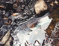
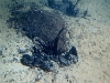
Natural oil seep at Tar Water Creek ...
Last access: 14.09.2009
|
|
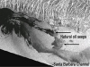
Natural tar seep offshore Gaviota, ...
Last access: 14.09.2009
|
|
Tar found floating in the ocean offshore Point Conception, ...
Last access: 14.09.2009
|
|
European Remote Sensing 1 satellite radar image ...
Last access: 14.09.2009
|
Supplement 2.5: Weathering of Oil on the Water Surface
|
Weathering of oil on the water surface
Last access: 14.09.2009
|
|
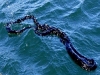
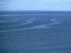
Oil spill at sea forming narrow bands
|
|
|
|
Testing the natural dispersion of oil due to waves at OHMSETT oil spill testing facility
Last access: 14.09.2009
|
|
Water channel at OHMSETT oil spill testing facility
Last access: 14.09.2009
|
Supplement 2.6: Operational Oil Discharges at Sea
|
Oil spill at sea
Last access: 14.09.2009
|
|
|
|
A bilge well in a ship
Last access: 14.09.2009
|

|
|
|
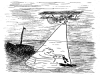
A cartoonist's view of airborne oil spill surveillance
|
Supplement 2.7: Accidental Oil Discharges at Sea
|
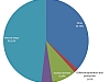
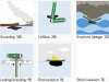
Grounding: 34% etc.
|
|
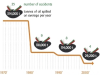
Number of oil tanker accidents causing spills ...
Last access: 14.09.2009
|
Supplement 2.8: Land-based Sources of Oil Pollution
|
Cleanup crews work to restore beaches ...
Last access: 14.09.2009
|
|
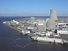
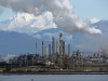
Anacortes Refinery Tesoro Corporation, ...
Last access: 14.09.2009
|
|
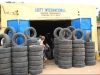
Worn tyres on sale in a shop in Gambia
Last access: 14.09.2009
|

|
Petrol station in St. Julians, Malta
Last access: 14.09.2009
|
|
|
Motorcycle washing in a private driveway
Last access: 14.09.2009
|
|
Sewage outfall in the Maldives
Last access: 14.09.2009
|
|
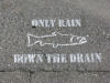
Only rain down the drain
Last access: 14.09.2009
|
Supplement 2.9: Contingency Planning in Oil Spill Response
|
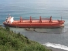
Bulk carrier grounded and leaking bunker fuel
Last access: 14.09.2009
|
|
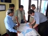
Regular communication between all parties ...
Last access: 14.09.2009
|
Supplement 2.10: Choices of Oil Spill Response
|
Spreading dispersants by airplane
Last access: 14.09.2009
|
|
Oil covers a beach on the Tuzla Spit in the Kerch Strait
Last access: 14.09.2009
|
|
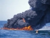
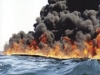
Oil slick on fire
Last access: 14.09.2009
|
|
Containment of an oil spill with a boom ...
Last access: 14.09.2009
|
Supplement 2.11: Impact of Oil on Different Types of Coasts
|
Sensitivity of intertidal ecosystems
Last access: 14.09.2009
|
|
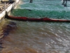
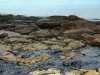
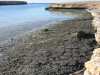
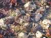
Oil on a rocky coast
Last access: 14.09.2009
|
|
Oil and tar washed ashore at the southern tip ...
Last access: 14.09.2009
|
|
Marsh near Fort Johnson, South Carolina ...
Last access: 16.09.2009
|
|
Coral transplanting as part of restoration activities ...
Last access: 16.09.2009
|
Supplement 2.12: Impact of Oil on Marine Flora and Fauna
|
|
A storm wrecked several ships, including an oil tanker ...
Last access: 14.09.2009
|

|
Marine food chain
|
|
|
|
Smelly fish
|
|
A reference condition of vegetation on land (France)
http://www.black-tides.com/uk/tools/learning-guide-understanding-black-tide.pdf page 58 (8.5 MB pdf file)
Last access: 16.09.2009
|
Supplement 2.13: Impact of Oil on Fisheries and Aquaculture
|
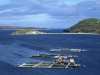
Salmon farm
Last access: 16.09.2009
|
|
Fishermen in Indonesia using gill net
Last access: 16.09.2009
|
|
Water quality testing on a shrimp farm
Last access: 16.09.2009
|

|
Fish are often the main food protein source for coastal communities ...
Last access: 16.09.2009
|
Supplement 2.14: Oil Spill Maps Based on Aerial Detection
|
Map of detected oil spills in the Baltic Sea ...
Last access: 14.09.2009
|
|
Map of the density of detected oil spills in the Baltic Sea ...
Last access: 14.09.2009
|
|
Map of detected oil spills in the North Sea ...
Last access: 14.09.2009
|
|
Map of the density of detected oil spills in the North Sea ...
Last access: 14.09.2009
|
Supplement 2.15: Visual Appearance of Oil Spills on the Water Surface
|
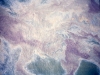
Part of an oil spill from 50 m3 of heavy fuel oil
|
|
Slicks on the water surface, from exudates of algae
|
Supplement 2.16: The Side-looking Airborne Radar
|
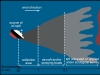
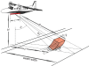
Geometry of SLAR operation and resolved surface area
|
|
The rough sea surface causes diffuse reflection of the radar wave
|
|
SLAR image of a ship seen as a white spot because of its high backscatter efficiency
|
Supplement 2.17: The Microwave Radiometer
|
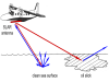
Geometry of microwave radiometer scanning operation
|
|
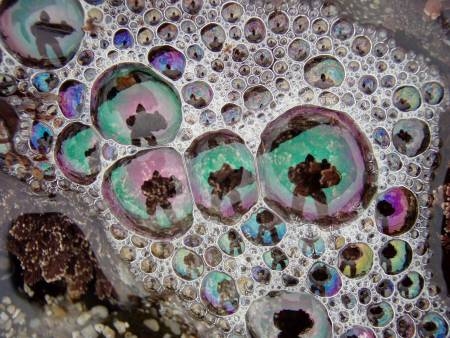
Interference colours seen in foam bubbles on the shore
|
|
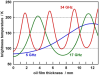
Brightness temperature of oil given in absolute ...
|
|
Heavy fuel oil slick with a total volume of 17 m3
|
Supplement 2.18: The UV-IR Scanner
|
Blackbody radiation
|
|
IR image of Forties crude
|
|
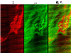
IR, UV and combined artificial image from an oil slick, detected in Spring 2000
Last access: 16.09.2009
|
|
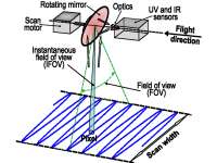
Geometry of the UV / IR line scanning operation
|
|
UV image of crude oil
|
Supplement 2.19: The Laser Fluorosensor
|
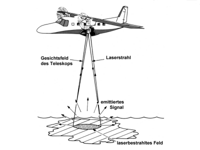
Measuring principle of the laser fluorosensor, analysis of an oil spill at sea
|
|
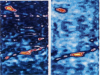
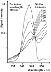
Left: a thick layer of lubricating oil is illuminated with UV laser radiation at 355 nm wavelength
|

|
Right: thin films of lubricating oil on a water surface are illuminated with the laser radiation and emit blue fluorescence
|
|
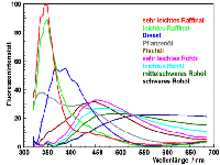
Fluorescence spectra of different oil types upon irradiation with UV light at 308 nm wavelength
|
|
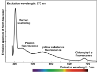
Emission spectrum of a water sample from the North Sea illuminated with ultraviolet light at 270 nm wavelength
|
|
Raman scattering of purified (i.e., non-fluorescent) water in the absence of oil...
|
|
Oil spill following a discharge of 1000 litres of crude oil
|

|
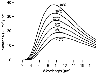
Data of a laser fluorosensor taken above an oil spill, see photograph in the left column
|
|
discharge - 4 min - 8 min - 14 min ...
|
Worksheets
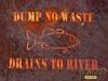
Worksheet c02-01: Role Play: Pollution Solution
|
Dump no water - drains to river
Last access: 16.09.2009
|
Worksheet c02-02-1: Airborne Oil Pollution Patrol 1: Visual Appearance of Oil on the Water Surface
|
A maritime surveillance aircraft.
|
|
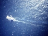
A ship spilling crude oil while underway, ...
|
|
Oil spill from a discharge of 1000 litres of light crude oil ...
|
Worksheet c02-02-2: Airborne Oil Pollution Patrol 2: Long-range Oil Spill Detection with Radar
|
A maritime surveillance aircraft with the long bar-shaped SLAR antenna ...
|
|
|
Image of the sea surface to the right of the aircraft, ...
|
Worksheet c02-02-3: Airborne Oil Pollution Patrol 3: Interference Fringes of Oil on Water
|
|
Brightness temperature of oil given in absolute temperatures (Kelvin scale), ...
|
|
|
Geometry of microwave radiometer scanning operation
|
|
Heavy fuel oil slick with a total volume of 17 m3, ...
|
|
|
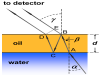
An oil layer with thickness d on the water surface, ...
|
Worksheet c02-02-4: Airborne Oil Pollution Patrol 4: Interference Fringes of Oil on Water: Supplement
|
|
An oil layer with thickness d on the water surface, ...
|
