1. Soil Degradation
Monitoring soil degradation from space
Soil degradation is a process fuelled by both natural causes and human activity. Depending on the causes and effects by which soil quality is degraded, we can distinguish soil erosion, desertification, salinisation as well as other processes which degrade the soil. For more information regarding the processes of soil erosion see this page.
By using remotely sensed data, it is relatively easy to distinguish between bare soil and vegetation. In addition, it also possible to identify some of the soil characteristics, such as its texture and humidity. For more information see this page.

Source: ESA
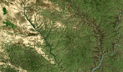
In many cases the effects of soil erosion are so intense and widespread that they are visible from space. The image above portrays the area of Huang He-Yulin in China, where wind and water are causing intense erosion (top left corner of the image).
For many years, the area has been used intensively for agriculture. In order to create more arable land, large areas were stripped of the forests. The demand for food production also led to intensive agricultural practices that produced high crop yields in the short-term, but severely reduced soil fertility in the process. Now, the area is susceptible to erosion due to the wind and rainfall, as there is no vegetation cover to protect the top-layer of the soil and gullies have been formed, through which the soil is being washed away during rainfall.

