1. Soil Degradation
Remote sensing of desertification
Remote sensing can be used to monitor the progress of desertification. The synoptic view provided by the satellites, in combination with the frequent provision of spectral data, makes remote sensing a very usefull monitoring tool. As desertification is a phenomenon that affects large areas, high spatial resolution is not as important, in comparison with the need for frequent coverage of large areas. As a result, medium spatial resolution instruments on satellites such as Terra (NASA) or ENVISAT (ESA) can provide data of sufficient quality.
For more information on the process of desertification, see this page.
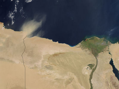
Dust storms, such as the one seen above from the MODIS satellite, are phenomena that contribute to the spreading of deserts. The wind is capable of transfering large volumes of sand from one area to the other. Sand dunes are constantly in motion, especially in large deserts where winds are very strong such as Sahara. The moving sand is "invading" areas neighbouring the desert and the deposited sand is affecting soil quality in those areas.
Question: What is the green area appearing on the right side of the image above?


