Ice in the Arctic Exercise 2: Looking at sea ice extent
Part 1: Background
In Chapter 5 we looked at sea ice extent in the Arctic. In particular we looked at how this extent changed from 1978 -2008.
Please note that the dataset used in this exercise is the 1979-2008 data as opposed to the 1978-2008 data used in the graphs from NSIDC.
The image on the right shows the overall trend, a 30 year decline in ice coverage with a rate of -8.6% per decade.
At the time we posed a question, does this 8.6% reduction tell the whole story; has the retreat of sea ice really been constant for the last thirty years?
In this exercise you will work through the data to find out.
If you want to get the original dataset you can download it from the NSIDC Sea Ice Index website. Alternatively we have provided the Sea Ice extent in September for the thirty year period of study in the table below.
Part 2: Calculating the 30 year percentage decrease
Take this data and put it into a spreadsheet program. We have used excel and the instructions refer to excel.
Start by selecting both columns and creating the graph that we already have above (right). Create it as a scatter or line plot.
When that is done right click on the data set and select add trend line. From the options select show formula on chart and show R2. The formula should be y=-0.0781x + 162.25. R2 is a measure of how well the trend line fits the data, a value closer to 1 represents a better fit.
Look at the graph that you have created (you will probably need to alter the axis to do this) and find the start and end points of the line of best fit. They should be about 7.74 and 5.54; this represents a decrease in sea ice extent of 2.2 million km2 over a thirty year period.
In order to work out the percentage change we divide the change by the starting value and multiply by 100. So in this case:
(2.2 / 7.74) x 100 = approximately a 28% change.
28% is obviously a fair bit more that the 8.6% we said sea ice extent had decreased by... What is going on?
The key is in the 8.6% per decade.
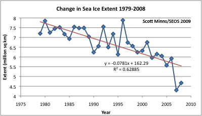
Source: Scott Minns/SEOS, data NSIDC.
Part 3: Calculating decadal change in extent to give percentage change per decade
You are now going to work out how the figure of 8.6% is calculated and think about how this figure compares with the actual data.
Try plotting the data in blocks of ten years and calculate the percentage change for each of these three periods.
What do the graphs show you?
What does the average change show?
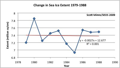
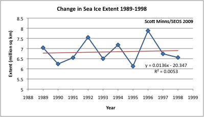
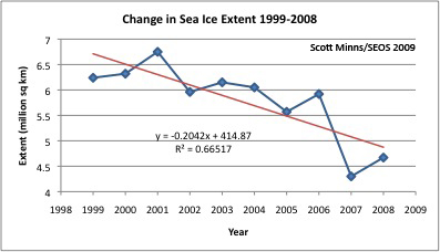
Now add the three answers together, and divide by three to work out the mean, this should be about -8.6% (depending on your rounding). This is how the average percentage change in sea ice per decade had been calculated.
If not why not?
Which time period has the greatest amount of change?
What does this tell us?
Does this worry you?
